

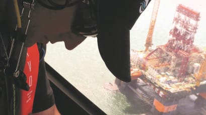
Aerial surveillance with regional reach: supporting timely oil spill detection and response efforts.
The West Africa Surveillance Platform (WASP) service enhances OSRL’s Tier 2 preparedness offering with dedicated aerial surveillance across the West African coastline. This enhanced membership coverage service is available to our members, offering access to a strategically positioned aerial surveillance capability.
Developed in partnership with Action-Air Environnement (AAE), the service operates two dedicated aircraft – a Cessna 337 based in Lomé, Togo, and a Piper PA-23 based in Libreville, Gabon. These aircraft are equipped with advanced fixed Medium Wave Infra-Red (MWIR) and Electro-Optical (EO) RGB sensors, delivering real-time intelligence and high-quality imagery to support verification and quantification of oil spills.
Covering a region that extends 150 miles offshore from the northern boundary of Mauritania to the southern tip of South Africa, WASP delivers fast and effective situational awareness during a response. Data captured during missions is securely recorded and available for review after landing, enabling your Incident Management Team (IMT) and regulators to make informed, timely decisions that drive resource optimisation.

WASP FAQs
-
No, the current aircraft are not configured for dispersant application. WASP is focused on surveillance and detection only.
-
Each flight collects imagery using Medium Wave Infra-Red (MWIR) and Electro-Optical (EO) Red Green Blue (RGB) sensors. This supports oil detection and helps verify and assess the extent of a spill.
-
The aircraft are held at a four-hour wheels-up readiness state, supporting rapid deployment when required.
-
WASP currently provides regional coverage across the West African coastline, from Mauritania to South Africa, extending 150 miles offshore.

Aerial surveillance remains one of the foundations of an effective spill response.
This informative field guide is designed to provides practical guidance on conducting aerial surveillance missions. Guiding on how to locate, assess, and quantify oil spills from the air to support effective response decisions.

View our surveillance, modelling and visualisation articles

Satellite Imagery: A Valuable Tool For Oil Spill Surveillance and Monitoring
TPR Seminar Series - Part Two: Surveillance, Modelling and Visualisation

ATSEA-2 Webinar Series - Part 2: SMV & Response Strategies

Upgrade your membership today.
Invest in preparedness and resilience.
With this enhanced membership coverage option, you can strengthen your capabilities, improve response efficiency, and better manage operational risks.
Simply fill in the form, and we'll get in contact with you.
If you would prefer to call us, pick up the phone to speak with our Preparedness Solutions team. We look forward to talking with you!
+44 (0)23 8033 1551
Regional numbers:
Asia Pacific
+65 6266 1566
Americas
+1 954 983 9880