

Real-time aerial insights to guide effective response
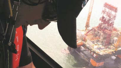
Aerial surveillance remains one of the foundations of an effective spill response. As technology advances, our capability to observe, analyse, and interpret data from above continues to evolve - ensuring rapid, accurate, and actionable insights. During an incident, the 'eye in the sky' feeds crucial information directly to the Incident Command, enhancing situational awareness and supporting confident decision-making.
Our Response Specialists can deploy on aerial surveillance missions using suitably equipped aircraft, verifying modelling predictions, response effectiveness, and environmental impact in real-time. This visual intelligence allows teams to validate strategic decisions and adapt quickly to varying conditions.
Integrated with oil spill modelling and satellite remote sensing, aerial surveillance forms part of a dynamic data ecosystemframework. But sometimes, collecting data isn't enough - visualisation tools can translate this complex information into intuitive formats, helping response teams understand unfolding events at a glance.
Together, surveillance, modelling, and visualisation represent three key pillars of intelligence to inform, support, and optimise spill response strategies.


Aerial surveillance remains one of the foundations of an effective spill response.
This informative field guide is designed to provides practical guidance on conducting aerial surveillance missions. Guiding on how to locate, assess, and quantify oil spills from the air to support effective response decisions.
Aerial Surveillance FAQs
-
We deploy our Response Specialists using suitably equipped fixed-wing or rotary aircraft, depending on regional availability and response requirements.
-
Absolutely. Our Satellite Radar Detection Service complements aerial missions, offering a broader spatial overview and enhancing overall situational awareness.
-
Aerial observations validate modelling outputs in real time, ensuring predictions align with the actual spill behaviour and supporting more accurate decision-making.
-
Yes. Data from surveillance and modelling is transformed into intuitive visual formats to support rapid interpretation and strategic decision-making during an incident.

View our surveillance, modelling and visualisation articles

Satellite Imagery: A Valuable Tool For Oil Spill Surveillance and Monitoring
TPR Seminar Series - Part Two: Surveillance, Modelling and Visualisation

ATSEA-2 Webinar Series - Part 2: SMV & Response Strategies

Accessing these services is quick and straightforward.
As an OSRL member, we can guide you through the use of these services alongside your ongoing incident.
As part of your core membership coverage, you can use these services by calling the Duty Manager or contacting us for more information.
Simply fill in the form, and we'll get in contact with you.
If you would prefer to call us, please pick up the phone to speak with our Duty Manager. Please always call for instant technical advice on using your core membership coverage services.
We look forward to talking with you!
+44 (0)23 8033 1551
Regional numbers:
Asia Pacific
+65 6266 1566
Americas
+1 954 983 9880